Copyright © Panorama Group 1991 - 2024

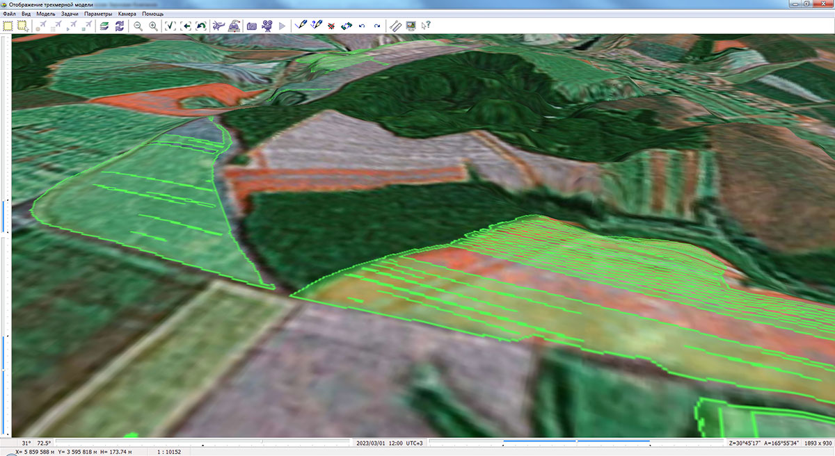
In KB "Panorama" is developed the version 5.3. The program is adapted for work with the vector, raster and matrix data, created by version 14. The new version of the program optimizes the construction of a hierarchical data tree of field passports and a switching between elements in the list of working arable land plots. The performance of processing and displaying information has been improved with a large (tens of thousands) number of records in the field passport database. Support of providers of access to the attributive data has been expanded and their loading at the time of program start has been accelerated. The help system has been updated and translated into a web-format. The tools for statistical data analysis and designing of farmland maps are built-in.
The new version supports tools of statistical data analysis. A type of programmable signs has been added into the agro10t.rsc classifier for . The diagram description includes a list of codes of semantics corresponding to sectors and/or columns of the diagram. Semantics are filled for a contour of an agricultural land. For example, requirement for nitrogen, phosphorus, potassium, acidity degree, humus content and others. The diagrams are updated automatically when the values of the characteristics of the work area change. Diagrams, together with the change in the color of the working area, can be used to visualize the state of agricultural land.
Support of service semantics influencing the size and color of a conventional sign, taking into account type of objects has been added. For example, for titles, in addition to the color, font type and height are available. By changing the values of the semantics of an object through the "Select Object" dialog, you can give individual features to the conventional signs of various objects, for example, change the color of the line or the background color of the polygon.
The has been updated. Into the "About" window the information on the licence was added: number, type and expiration date of the license, as well as the expiration date of technical support.
GIS "Panorama AGRO" is designed to automate the management of the farming system of enterprises. The system allows you to create and edit the boundaries and attributes of agricultural land, plan agrotechnical activities, prepare tasks for drivers and machine operators, calculate indicators of actual performed works, and generate relevant reports.
In addition to the GIS "Panorama AGRO", the range of programs for agriculture includes "Workstation of agronomist" and . Professional GIS "Panorama" is intended for preparing cartographic data. Storage, protection and authorized access are provided by the . Programs are fully compatible at the level of data. This allows you to create scalable systems of any complexity at the corporate, regional and federal levels.
The new version of the program is available for download in the section.


KB "Panorama" together with have presented on a "Import substitution. Transition to domestic services in digital economy",which took place on June, 25th, 2022 as part of the .
The event was chaired by the Minister of Communications and Informatization of the Republic of Belarus K.K. Shulgan and Deputy Governor of the Kursk region O.A. Krutko. Representatives of the regional administration and leading enterprises of the Russian IT industry discussed the introduction of digital services for agricultural producers and issues of their import substitution.
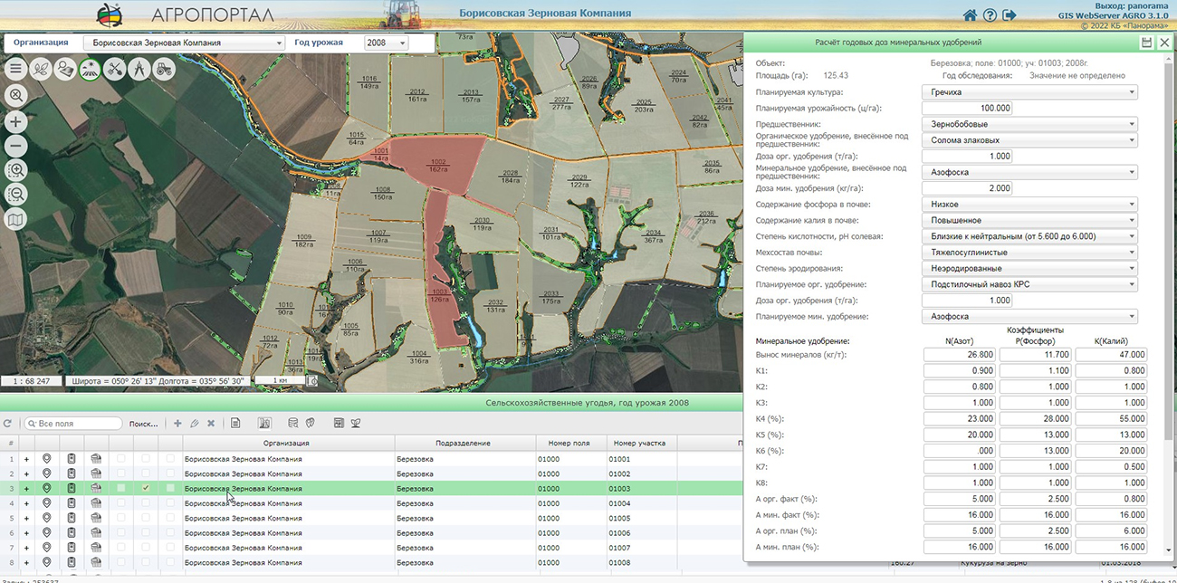
GIS WebServer AGRO consists of a number of software modules that together allow you to build complex distributed and scalable information systems at the level of regional government that ensure the maintenance of the land bank of the region. The cartographic database operates under the control of the , the publication of spatial information on the web is carried out using .
The application is designed to process information about agricultural lands and accounting objects of agricultural enterprises, including arable land characteristics, crop rotation information, cadastral data, data of vehicle monitoring, agrochemical calculations of mineral fertilizer doses, and others.
Among other things, it has been reported about successful application of GIS WebServer AGRO as the basic component of the module of accounting the agricultural land of the .
You can get acquainted with an example of the work of GIS WebServer AGRO on the page of the demonstration project.


In KB "Panorama" the version 3.1 has been developed. The new version adds the ability to keep records of the processing the fields with plant protection products (PPP) with use of the information from the unified directory of pesticides and agrochemicals. For each field, a list of plant protection products is formed, taking into account the order of application, date and type of processing (ground or from air) of plants.
The unified reference book is filled with information from the State catalog of pesticides and agrochemicals approved for use on the territory of the Russian Federation and contains the name of the active substance, the hazard class for humans, and the hazard class for bees in the field conditions. One of the main reasons for the death of bees in many countries of the world, including Russia, is the steady increase in the use of pesticides in agriculture. According to the appraisal of management of the , recently the volume of pesticide use in Russia has increased annually by 6-8% and this trend will continue for a long time. The list of pesticides and agrochemicals registered in Russia includes more than a thousand items. However, today no one knows exactly what preparations and in what quantities are applied by agricultural producers. The use of a unified directory of pesticides and agrochemicals makes it possible to unify the calculation of the danger of using plant protection products for people and bees.
In new version of GIS WebServer AGRO the possibility of work with projects has been expanded that allows to set automatically project's settings (current organization and crop year). There are added a loading and selection of multipoint objects in the map, the ability to create and edit objects of the "Polygon with a point" type. "Map Editor" and administration module have been updated.
Synchronisation of the cartographical information described in base "Panorama АГРО" and the information published in , is carried out automatically.
For collective work with the data the digital maps of farmland and an enterprise infrastructure are placed on the . Its application allows you to synchronize the work of the desktop , web applications and mobile clients. Desktop applications such as , "Workstation of agronomist" and others can be connected to the GIS Server. It allows the mobile clients working through web, to process the same data together with desktop clients. You can get acquainted with an example of the work of GIS WebServer AGRO on the page of the demonstration project.
The new version of the program is available on the website in the section.


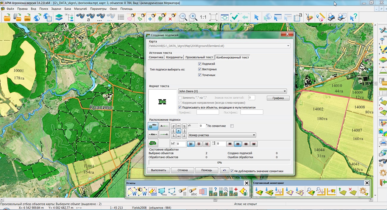
In KB "Panorama" the version 14.2.0 has been developed. In the new version there are updated the tools of statistical analysis of data, designing of farmland maps, preparation of remote sensing data, the reports printing.
In the program the new view of programmed symbols for has been added. The description of the diagram includes a list of codes of semantics corresponding to the sectors of the diagram. The semantics are filled at the areal object - the contour of the agricultural land. For example, yield (t/ha), volume of applied fertilizers (t/ha), amount of applied plant protection products (t/ha), spent fuel and lubricants (l/ha) and others. The diagrams are updated automatically when the semantic values of the arable land's contour change. Diagrams in combination with changing the color of the field contour can be used to monitor the state of agricultural land.
When setting up diagrams for each semantics its own parametres of displaying sector (color of filling, contour color, filling by hatching, and others) are set. For the entire diagram, the parameters of the contour line and the size of the diagram radius in mm are set. The sector size will correspond to the share of the value of the semantics in the sum of values of all semantics. Diagram parameters, including scalability and limits for zooming in and out, are customized in the map classifier. To prepare a map for the purpose of monitoring information about agricultural lands using diagrams, the task has been added. In the "Combined text" mode, the task carries out drawing of titles onto a map in the center of areal objects. Further, the title are recoded into a point object "Diagram". At the same time, logical links are formed for areal (field contour) and point (diagram) objects that provide automatic updating of diagrams when updating the semantics of areal objects.
The task has been improved. Import of rasters of format MrSID (SID, JPEG2000, NTF, ECW) has been added. The MrSID format is used to compress raster graphics. By means of this format, packed huge raster images such as aerial photography and satellite photos can be quickly viewed piecemeal without the need to unpack the entire file.
The task has been improved. Ability has been added to page-by-page save the printed areas to JPG, PNG, TIF and PDF graphic files. When saving in JPG, PNG, TIF formats the number of files corresponding to the number of selected pages is formed. The file name contains file name and page number, for example, noginsk_1.jpg. When saving to PDF, it is generated one multi-page document.
The new version of the program is available for download in the section.


On December 23, 2021, an online intensive the took place. The event was organized by the . More than 70 representatives of universities who are interested in introducing information technologies of advanced agricultural enterprises into the educational process, a forming the IT competencies of students of the trained ones.
Representatives of KB "Panorama" made a presentation on the topic . During the speech, the main capabilities of were identified, as well as its real application as a module for accounting for agricultural lands of the region was demonstrated.
GIS WebServer AGRO is a system of software modules that together make it possible to build complex distributed and scalable corporate information systems that provide automation of business processes for agricultural management of an agricultural enterprise. is used as a source of cartographic data. The database of cartographic data is operated by the . The configuration of the sectoral database of soil fertility is carried out using the .

Тел.: +7 (495) 739-0245, +7 (925) 221-1603
www.gisinfo.ru | panorama@gisinfo.ru
105005, Russia, Moscow, Baumanskaya Street 7, building 1, office 229 (m. Baumanskaya)
Copyright © Panorama Group 1991 - 2024


 Mobile version
 Full version