Copyright © Panorama Group 1991 - 2024

KB "Panorama" has developed version 3.2. In the new version, the construction of a hierarchical tree of field passports data and switching between elements in the list of arable land plots have been improved. The performance of displaying information has been enhanced when dealing with a large number of field passport records in the agricultural database. The functionality for working with cartographic projects of producers has been expanded in GIS WebServer AGRO, and their automation has been implemented in the administration module.
The management of field treatment accounting using plant protection products (PPP) has been optimized by utilizing information from a unified directory of pesticides and agrochemicals. A periodic check for connection to the remote data publication server has been added in case the remote server was unresponsive when opening a layer. This allows for connection restoration and retransmission of necessary requests. The data display speed during geospatial portal publication has been increased. Improved support for reading large maps (tens of gigabytes and above) on slow hard drives during simultaneous multi-user editing of these maps has been implemented.
GIS WebServer AGRO utilizes as a spatial data source. Synchronization of cartographic information described in the agricultural database and information published on GIS WebService SE is automatic. For collaborative data work, digital maps of agricultural lands and enterprise infrastructure are hosted on the . Its application enables synchronization between desktop "Panorama AGRO", web applications, and mobile clients. Desktop applications such as , "Workstation of agronomist", and others can connect to the GIS Server. This allows mobile clients working through the web to process the same data jointly with desktop clients.
To see an example of GIS WebServer AGRO in action, visit the demonstration project page. The new version of the program is available for on the website.


In the KB "Panorama", the software complex version 15.2 has been developed. In the new version, has been expanded. Additional layers from the Rosreestr geospatial portal are connected - Thematic Maps: Cadastre value of land plots, Land categories, Types of permitted land use, Lands for construction, Lands for tourism.
During land management, thematic maps allow for a quick visual assessment of a particular territory. For example, the map of cadastre value of land plots has 5 gradations: up to 3 million rubles, from 3 to 15 million rubles, from 15 to 30 million rubles, from 30 to 100 million rubles, and over 100 million rubles. Land category map - 8: not established, agricultural lands, forest fund, water fund, specially protected areas, settlement lands, industrial lands, reserved lands. The map of types of permitted land use contains over 220 gradations.
An important set of tools for a GIS specialist in creating infrastructure maps for agriculture is processing lists of objects. In the new version of the program, the corresponding dialog has been updated. The ability to cut and split objects belonging to complex lists containing objects from one or several maps opened in one window has been added.
To ensure consistency of symbol libraries on client machines, from the GIS Server has been added. Classifiers located on the server will be automatically updated on the client.
For more flexible data preparation for printing, in the dialog on the "Numbers" tab, the ability to set a unique object number that will temporarily not be visible on the map has been added.
The new version of the program is available for download in the section.


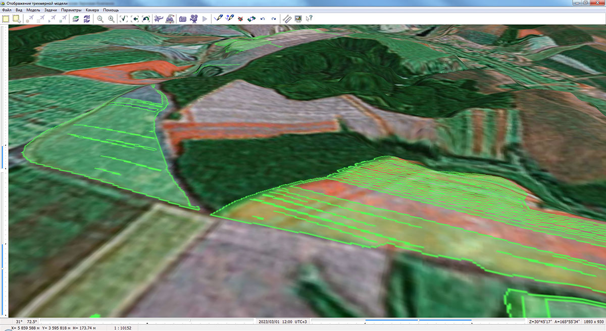
In KB "Panorama" the version 15.1.2 has been developed. In the new version, the "Satellite-based field recognition" mode has been updated, the dialog and the task have been improved. The integrated application of the "Workstation of agronomist" modes implements automated technology for maintaining a land bank and soil fertility base.
The updated mode ensures recognition of the boundaries of agricultural land contours based on Earth's remote sensing data. The program interacts with the Mapflow.ai service and, using a neural network, automatically deciphers and delineates the boundaries of working areas of arable land. The new version changes the user authorization protocol for the service, including the use of tokens issued in the user’s personal account. Information processing is performed in a local area limited by the polygon indicated on the map. The construction area can be specified by a rectangle or an arbitrary closed polygon. The construction of a vector model of working areas of arable land is carried out on the basis of automatically selected current remote sensing data of medium (10 m/px) and high resolution (1.2 m/px). In the new version a recognition of fields boundaries from Sentinel-2 images has been added. The vector data constructed by means of service is automatically loaded into the from GeoJSON format onto a map of the working areas of the agricultural enterprise. The field map is used to maintain field passports, construct thematic cartograms, obtain vegetation indices, maps of heterogeneity and nitrogen requirements, calculate the application of fertilizer doses and other agrotechnical calculations.
In the process of maintaining a land bank for an agricultural enterprise, the boundaries of field contours are often compared with the boundaries of cadastral objects. Determination of intersections and overlaps is performed using the mode. For clarity of the results of the analysis of the relative position of various groups of objects in the form of thematic layers, the "Lists of objects" dialog has been improved. Possibility of displaying list of objects by style (conventional symbol) customized by the user has been added. In the "Lists of objects" dialog, custom styles are automatically formed for the selected lists of objects. Custom styles for displaying lists of objects are a set of conventional symbols for polygons, lines and points. Style sets can be combined into themes. New features allow you to quickly add lists by selected objects on the map and perform tasks with lists: Building a zone around objects of the selected list, Cutting objects, Union of objects, Building the areas of objects crossing.
The application task "Map Legend" has been improved. Display of named lists of objects in the legend dialog has been added. Enabling and disabling the visibility of object lists is done by simply clicking the left mouse button on the icon corresponding to the list. On the map, lists of objects are displayed as separate thematic layers in accordance with user-customized legends. The composition and order of display of thematic layers in the general data list is controlled by enabling and disabling the visibility of the list of objects in the bottom panel. The convenience of designing the appearance of thematic layers has been improved: assigning a style and color to the list of objects has been added. Simple addition of selected objects into the list with automatic formation of names has been implemented.
The new version of the program can be downloaded on our website in the section.


In KB "Panorama" the version 14.5.7 has been developed. In the program for performing an analysis of the relative position of the contours of agricultural land used for farming, and the boundaries of land plots registered in the cadastre, a number of modes have been improved. Objects of the account, both an arable land, and cadastral objects, are often represented on the map by a multipolygon. For the analysis of complex geometry, the modes , and have been improved. The new version of the program analyzes intersections with all external and internal contours. In the modes dialogs, the names of the elements have been changed to more accurately characterize the process of calculating the relative position of objects. In the "Object intersection calculation" mode, the recording of semantics in objects from list 2 has been optimized. In the "View object intersection" mode, the algorithm for calculating the total area and percentage of intersection for objects in list 2 has been improved.
The task of has been improved. There are added the layers from the server of KB "Panorama" and the geoportal of the RGIS of the Ryazan region with many layers of data, including industry data: Agricultural land, Forest-park green belt, regional protected areas, nature management, industrial enterprises and others. There is improved the algorithm for scaling images from geoportals with exceeding the virtual sizes of the image in width and height of 2 Gigapixels or more, which is necessary when detailing the image at a scale larger than 1: 100.
The task has been improved in terms of auxiliary modes for editing points. When editing points of an areal object, pressing the "Q" key disables a sign of a rectangle or if this sign is absent, brings the object to a rectangular shape (straightens the corners). Function of quick recording of the edited object by pressing the "hot" key "S" has been added. In the dialog for selecting the created object for the mode, there is added a support for the class hierarchy, presented as a tree of layers/classes. The selection of objects is carried out taking into account localizations, layers and classes. The list of selected objects is presented in the form of the table which contains the information about localization, a code, a key, a name and a class of objects. The search by all objects of the classifier has been improved with the ability to filter the table by individual localizations. In the mode of searching by selected objects, all used localizations are set, and when moving in the table of objects, a class is indicated in the tree of layers/classes.
The new version of the program is available for download in the section.


In KB "Panorama" is developed the version 5.3. The program is adapted for work with the vector, raster and matrix data, created by version 14. The new version of the program optimizes the construction of a hierarchical data tree of field passports and a switching between elements in the list of working arable land plots. The performance of processing and displaying information has been improved with a large (tens of thousands) number of records in the field passport database. Support of providers of access to the attributive data has been expanded and their loading at the time of program start has been accelerated. The help system has been updated and translated into a web-format. The tools for statistical data analysis and designing of farmland maps are built-in.
The new version supports tools of statistical data analysis. A type of programmable signs has been added into the agro10t.rsc classifier for . The diagram description includes a list of codes of semantics corresponding to sectors and/or columns of the diagram. Semantics are filled for a contour of an agricultural land. For example, requirement for nitrogen, phosphorus, potassium, acidity degree, humus content and others. The diagrams are updated automatically when the values of the characteristics of the work area change. Diagrams, together with the change in the color of the working area, can be used to visualize the state of agricultural land.
Support of service semantics influencing the size and color of a conventional sign, taking into account type of objects has been added. For example, for titles, in addition to the color, font type and height are available. By changing the values of the semantics of an object through the "Select Object" dialog, you can give individual features to the conventional signs of various objects, for example, change the color of the line or the background color of the polygon.
The has been updated. Into the "About" window the information on the licence was added: number, type and expiration date of the license, as well as the expiration date of technical support.
GIS "Panorama AGRO" is designed to automate the management of the farming system of enterprises. The system allows you to create and edit the boundaries and attributes of agricultural land, plan agrotechnical activities, prepare tasks for drivers and machine operators, calculate indicators of actual performed works, and generate relevant reports.
In addition to the GIS "Panorama AGRO", the range of programs for agriculture includes "Workstation of agronomist" and . Professional GIS "Panorama" is intended for preparing cartographic data. Storage, protection and authorized access are provided by the . Programs are fully compatible at the level of data. This allows you to create scalable systems of any complexity at the corporate, regional and federal levels.
The new version of the program is available for download in the section.


Тел.: +7 (495) 739-0245, +7 (925) 221-1603
www.gisinfo.ru | panorama@gisinfo.ru
105005, Russia, Moscow, Baumanskaya Street 7, building 1, office 229 (m. Baumanskaya)
Copyright © Panorama Group 1991 - 2024

 Mobile version
 Full version